Eye2Sky Network
Highly resolved regional satellite & sky cameras nowcast for grid management and the energy market
Partner: DLR
Actors involved: Forecasting Services Provider, DLR VE, DLR SF
Context |
Decarbonization of the human society requires a significant integration of renewable sources like solar and wind power into the electrical grids. The intermittent nature of these sources causes new technical challenges that need to be tackled. Accurate high-resolution weather and renewable energy forecasts could help to optimize operations of storage facilities and support power systems in order to balance fluctuations induced into the electrical grids.
Summary |
The new innovative Eye2Sky network located in North-West Germany combines various remote sensing technics including radiometers, sky images and satellites over an area of roughly 10.000 km².
This worldwide unique setup provides a regional highly resolved nowcast/forecast of solar irradiance. The network also offers the possibility to validate other less resolved forecasting approaches (satellites and NWPs) in other regions.
This network is already partially in operation and will be finalized within the next months. In addition, other forecast providers could use the highly resolved data to validate their approaches.
Challenge |
How to use a network of sky cameras and satellite images to obtain a very high spatial and temporal resolved regional nowcast?

Approach |
Introduce high-resolution sky camera forecasts on the irradiance forecast chain to improve forecasting products.

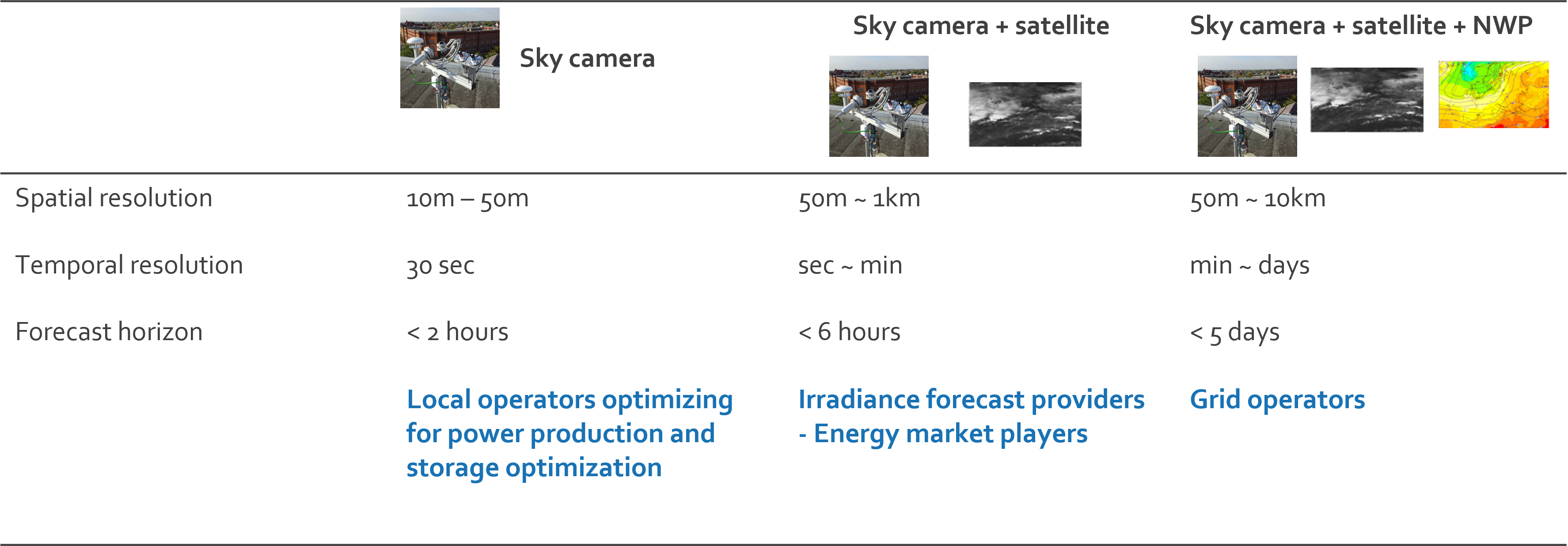
The use of the highly resolved network of sky cameras allows to increase the temporal and spatial resolution of the regional forecast (Eye2Sky region). The combination of different sources and measurements enables to optimize forecasts. Finally, high quality data for calibration/validation (satellite, NWP, …) are provided. Sky cameras and satellite images enhances improvements on the regional electricity management (storage, ramps, fluctuations) as well as more accurate information for electricity market operations.
Innovative content of forecasting solution
The Eye2Sky network will provide for a large area in northwest Germany solar irradiance nowcasts/forecast with until now unseen spatial and temporal resolutions and potentially lower uncertainties. Furthermore, the Eye2Sky network provides a highly resolved validation data set for satellite and NWP based forecasting systems. Supporting the further development of these forecasting approaches.
KPI 1 Increase of spatial and temporal resolution of regional forecasts from km -> m, min -> sec
KPI 2 Continuous system validation based on moving error metrics distributions discretized for distinct solar irradiance conditions.
For more information, please refer to the following web article.
