We are pleased to announce that the German Aerospace Center (DLR) has released the latest Smart4RES web article about: Multi-source observations to improve solar forecasting within the Smart4RES project.
Multi-source observations to improve solar forecasting within the Smart4RES project
Bijan Nouri1, Jorge Lezaca2, Annette Hammer2, Niklas Blum1, Arindam Roy2
1) German Aerospace Center (DLR) Institute of Solar Research
2) German Aerospace Center (DLR) Institute of Networked Energy Systems
Why advanced solar forecasting methods are so important
The decarbonization pathway to a net-Zero Europe requires a significant integration of renewable sources like solar power. The continuous growing share of solar power penetration combined with the intermittent nature of solar energy creates challenges for solar power plants as well as the electrical grids. These challenges are even more pressing when thinking about modern reactive “smart” grids with distributed energy generation, as well as demands for bi-directional energy flows, integrated storage capacities and the resulting dynamic pricing.
Therefore, forecasting the expected solar resources becomes increasingly important for the stable operation of these essential infrastructures. Depending on the stakeholders needs and prevailing ambient conditions, different kind of forecast horizon as well as temporal and spatial resolutions are needed. E.g. short term forecast for the next minutes or hours ahead are helpful to optimize the operation of backup systems dedicated for ramp rate control. It might be even possible to reduce the needed backup system capacities up to render them completely needless. Larger forecast horizons are essential for energy scheduling as well as managing power balancing. However, potentially large errors of forecasts will lead to additional operation and maintenance challenges and costs due to accelerated degradation of technical facilities, as well as to unfavorable assessment of electricity prices or increased balancing power demands. Therefore, the forecast accuracy for different time scales and resolutions is key for a grid with a significant share of solar power penetration.
State of the art in solar forecasting
Overall three main approaches exist for solar irradiance forecasts.
- Local observations (e.g. radiometers, ground based cameras) can provide forecast for the next minutes ahead. Such forecasts can provide resolutions ≤1 min for time and ≤10 m for space. However, limitations in coverage and forecast horizon exist. The coverage is indeed restricted to the immediate surroundings of the local observation and to horizons ranging from a few minutes to about half an hour.
- Forecast from geostationary meteorological satellites cover large continental areas with typical resolutions between 2-10 km in space and 15 minutes in time, while achieving reliable forecast horizons up to 6 hours ahead.
- Numerical weather predictions (NWP) describe the state of the atmosphere at a given time. NWPs are based on a set of differential equations, which describe physical and chemical processes in the atmosphere, surface, seas and soils starting from an initial state while considering pressure, temperature, wind, water vapour, clouds, etc. Some relevant processes take place under very small spatial resolutions, which cannot be covered making approximations based on parameterization necessary. For the described application resolutions of ≥1 hour in time and ≥1 km in space are typically achieved with horizons of a couple days ahead.
How does Smart4RES revolutionize solar forecasting?
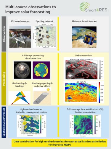
Within Smart4RES, DLR is working together with its partners on possibilities to increase solar forecasting accuracies. The so-called Eye2Sky network, established in north west Germany, has been used to develop an advanced forecasting method. In its final stage this network will include more than 39 stations with all sky imager (ASI), radiometers and ceilometers. The backbone of the network are the ASIs. ASIs are ground based cameras which take fully hemispherical images of the sky. Sky images are processed to extract information which includes cloud detection, cloud tracking & geolocating, shadow projection and analysis of radiative effect [1,2 & 3]. Finally, all processing steps are combined to create irradiance maps for the current conditions as well as forecast for the immediate future. By interconnecting all elements of the network and exploiting the redundancies, irradiance forecast with the resolution and accuracy of local observations are achieved, while covering an area >10,000 km² with horizon up to 2 hours ahead. Using the Meteosat geostationary meteorological satellites and the Heliosat method, DLR also produces irradiance maps for the Eye2Sky area with a coarser resolution (2 km / 15 min) and consequently forecasts with a higher time horizon (up to 6 hours ahead) [4]. DLR aims to improve the accuracy of the regional forecast by combining the satellite with the ASI based forecasts. This combination will lead to high resolved seamless forecast for the area covered by the Eye2Sky network. Additionally, the use of the NWP forecast Arome [5], from the project partner Météo France, will be studied on the forecast combination to assess the advantages that this NWP data can bring to the seamless regional forecast. Furthermore, the project partner Whiffle will investigate the potential of data assimilation for local weather forecast from Large Eddy Simulations (LES) [6]. The high-resolution data from ASIs could help defining the initial state of the LES, which in turn can produce accurate and high-resolution local weather forecasts.
Conclusion
Smart4RES develops complementary methods to blend information from multiple sources of data and to propose novel approaches towards a seamless view of renewable energy system forecasting at various temporal and spatial granularity levels. The Project’s partners are investigating the potential of combinations between different local and satellite-based observations as well as NWPs for improved solar irradiance forecasts. First preliminary results show significant potential of the Eye2Sky network that combines in its final stage all sky imager, radiometers and ceilometers. This network can produce highly resolved and accurate solar forecast covering an area >10,000 km² while archiving horizons up to 2 hours ahead. Further improvements are expected by including Meteosat and Arome data. In addition, the potential of data assimilation in LES with local observations from ASIs will be investigated.
References
[1] Fabel, Y., Nouri, B., Wilbert, S., Blum, N., Triebel, R., Hasenbalg, M., Kuhn, P., Zarzalejo, L.F., & Pitz-Paal, R. (2021). Applying self-supervised learning for semantic cloud segmentation of all-sky images. Atmospheric Measurement Techniques Discussions, 1-20.
[2] Nouri, B., Wilbert, S., Segura, L., Kuhn, P., Hanrieder, N., Kazantzidis, A., Schmidt, T., Zarzalejo, L.F., Blanc, P., & Pitz-Paal, R. (2019). Determination of cloud transmittance for all sky imager based solar nowcasting. Solar Energy, 181, 251-263.
[3] Blum, N. B., Nouri, B., Wilbert, S., Schmidt, T., Lünsdorf, O., Stührenberg, J., Heinemann, D., Kazantzidis, A., & Pitz-Paal, R. (2020). Cloud height measurement by a network of all-sky-imagers. Atmospheric Measurement Techniques Discussions, 1-29.
[4] Hammer, A., Kühnert, J., Weinreich, K., Lorenz, E. (2015) „Short-Term Forecasting of Surface Solar Irradiance Based on Meteosat-SEVIRI Data Using a Nighttime Cloud Index.“ Remote Sensing 7, Nr. 7 (2015): 9070. doi:10.3390/rs70709070.
[5] Seity, Y., Brousseau, P., Malardel, S., Hello, G., Benard, P., Bouttier, F., Lac, C., Masson, V., 2011. The AROME-France convective-scale operational model. Monthly Weather Review 139 (3), 976–991.
[6] Schalkwijk, J., Jonker, H. J. J., Siebesma, A. P., & Van Meijgaard, E. (2015). Weather forecasting using GPU-based large-Eddy simulations. Bulletin of the American Meteorological Society, 96(5), 715–723.
Download the article: [Smart4RES] DLR web article
To view the graphical: [Smart4RES] Graphical abstract